A look at two housing developments in Thurrock from the last 100 years, and one for the next 100, which show how the places that get built for us to live in reflect and reproduce the dominant ideas, and the relationship of class forces, in society at the time they are developed.
1920s: “Homes fit for for Heroes“
In the immediate aftermath of World War 1, and with the Russian Revolution haunting their imaginations like a nightmare, the powers that be in Britain embarked on a period of mass affordable social housing for rent run through local authorities to maintain decent standards and accountability. Council houses. Until widely denigrated in the 1970s in the run up to “Right to Buy” a solid, affordable and secure place to live, generating an income from the council that paid off the initial loan taken out to build them, pay for maintenance and improvements, and provide a steady income once the loans were paid off.
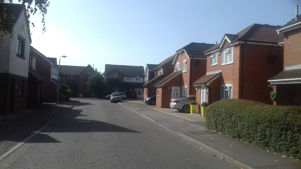
The Grays estate of over 1,000 homes pictured above was built in the mid 1920s and was one of those. I have to declare an interest at this point. I grew up on this estate. One of my great uncles knocked in the posts that laid out the road plan. My Dad was born on it in 1930, my mum moved to it as a toddler; and they still live there now at the age of 93.
These were standard designed “family homes” with three bedrooms – a big one, a middle sized one and a little one, a bit like the Three Bears. There was an outside toilet for each house – not shared like they would have been in a tenement, a small front garden and a more substantial allotment out the back for people to grow vegetables, like nearly everyone did at first, and, in some cases, keep chickens, as some still did as late as the 1960s. Early on, nearly every one had substantial posts for washing lines, many acquired one way or another via the docks; many of them, like ours, former ships masts. Nearly everyone did washing on a Monday and there was almost a competition to get the washing up on the lines first; almost like flying a flag.
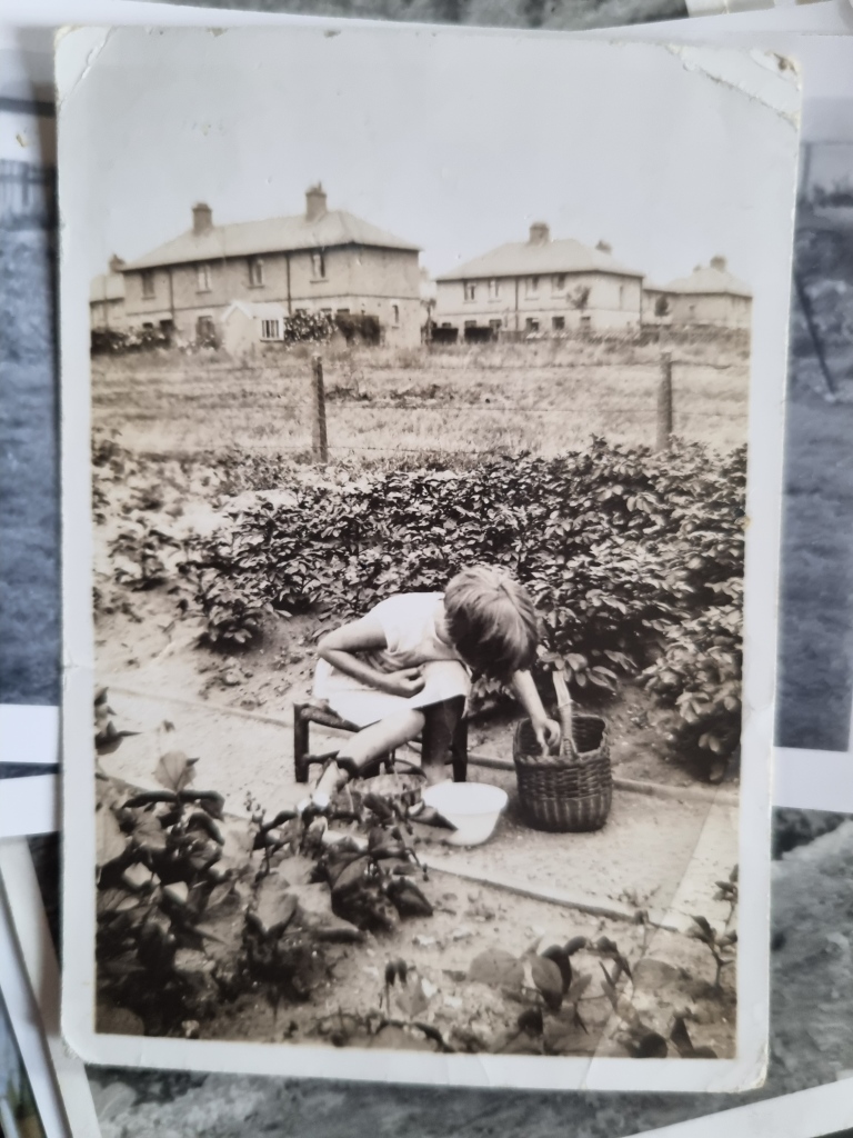
My Mum as a child shelling peas in the back garden of her parents house, circa 1936 or 7.
Smack in the middle of the estate was a recreation field with a small set of children’s play equipment in the North Eastern corner. Until after WW2 the influence of Sabbatarianism meant that every Sunday a Council employee would clank through the field wreathed in chains “like Marley’s ghost”, as my dad put it, and chain up the swings and merry go round; so the Sabbath would not be defiled by the satanic influence of children having fun. And, although there was one off licence in a small parade of shops, grocers, chippie, Co-op, post office, there was no pub. This may have been because the Old High Street down by the river – and easily in staggering distance -was full of them, but it gave the place a sober character; no one reeling home singing after closing time.
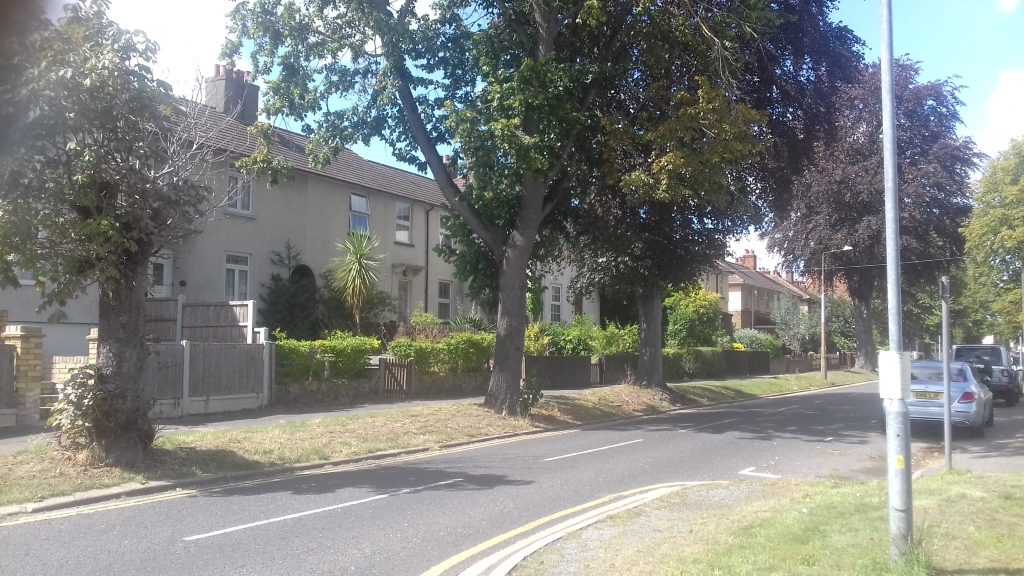
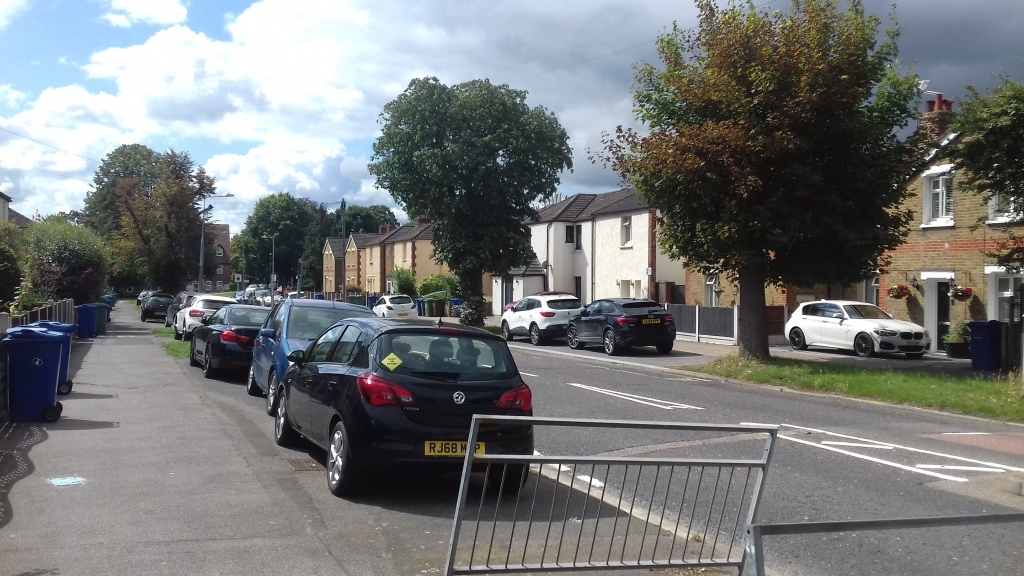
Built long before mass car ownership, the streets gave access to van or horse and cart delivery for the coal merchants – as heating was from coal fires – and groceries. Each road was bordered by a grass verge planted with trees at regular intervals, with every other tree a flowering variety like Horse Chestnut. This arrangement is still intact in places, as in the picture above. In the picture below more than half of the trees have been cut down, and the grass verges have been paved over in the last 30 or 40 years to provide parking bays for cars; which makes the streets feel more bare, less nurturing. This goes along with privet hedges being grubbed out and either replaced with fences or left open so paved over front gardens can provide space to park even more cars.
This coincided with the impact of Right to Buy. In 1979, the Council had upgraded the whole estate, remodelling both floors in each house to build in (two) inside toilets, open up the kitchens and take out the pantry storage spaces that had been superseded by most people having fridges by then. This was done by decanting tenants into other, similar houses while the work took place, block by block, on a standard model using economies of scale. It was a triumph of social provision. Paradoxically, this made the upgraded houses a very desirable purchase when the Thatcher government went on its “Property Owning Democracy” drive in the early 80s. As houses were sold off, with no right for the Council to use the proceeds to replace the stock, little marks of difference started to appear. Different front doors or windows. The occasional column. Some stone cladding. A little lion on a gatepost.
This did not have the desired political effect. The ward this estate is in has always – always– returned Labour councillors; and still does, by some margin. Not that it was ever politically homogenous. Even in the sixties, when the whole area was industrial working class and the Labour vote was weighed as much as counted, there were clearly identifiable Tories here and there – having the Daily Express delivered, wearing blazers with silver buttons, putting Pirate Radio Station stickers in their car rear windows (while looking like the sort of people who wouldn’t listen to them in a million years). During the 2017 election, when Thurrock was a three way marginal between Labour, Conservative and UKIP, a walk through this estate turned up so many Labour posters and garden stakes that it looked like a shoo in for Polly Billington. In the end, she came second, 500 votes behind the Conservative and a little ahead of the Kipper. Close run thing, but indicative the widely polarised political character of different localities in the same Constituency.
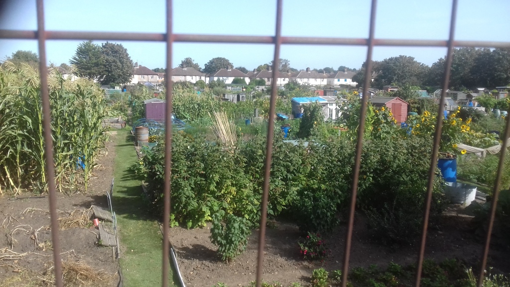
This estate was, and is, also buttressed by allotments that are still well used. This is a view from Hogg Lane, with Chafford Hundred, the alternative universe viewed below, behind and out of sight on the other side.
A final point to note is that a substantial minority of the houses have been enveloped with insulation and look oddly fatter and, being painted white, almost continental. Its not clear how many of these are remaining social housing and how many are those that have been bought. But it is clear here as well as in most other streets you can walk down in the UK that most people with limited wealth at the lower end of the “home owning democracy” can’t afford to make the changes that are socially necessary as individuals; meaning they have higher carbon emissions than they need have, and the higher bills to go with it. An eloquent demonstration of the limits of the market, and transition by piecemeal consumer choice. A wholesale retrofit doing all the houses in one go, with all the benefits of economies of scale on the same model as the 1979 refurb, would be more effective; and is another example of what neo-liberalism has cost us.
1980s: Chafford Hundred, by contrast, is almost an embodiment of what might be called Late Thatcherism. This is a huge development of 5,600 houses built on the land above the old worked out chalk pits on a derelict farm, between Hogg Lane in Grays and Lakeside by the Dartford Crossing; and is a classic piece of late 1980s urban redevelopment, named after an ancient Anglo Saxon County division that once extended from Brentwood to the river, Ongar to Childerditch. It sounds reassuringly retro with undertones of chaffinches and chaff from wheat fields. Almost rural and bucolic. An Essex echo of dreamy little towns in the Chilterns.
But, what’s in a name?
The architecture is box pastiche – standard boxes with historic local style flourishes to give “character” and instant “heritage” – all jammed together a bit too closely for privacy and ease, but too separate for community – snaking around curving roads that lead nowhere but to each other. There is no real centre to it. It feels like an American suburb shrunk to meaner English dimensions.
A few little shops and a doctors surgery with everything retail sucked into the enormous commercial gravitational field of the Lakeside Shopping Centre, on the far side of a foot bridge over the railway line.
There’s only one tiny park for the kids, unless they want to trek off down the pits, which have been remodelled as nature reserves, so the developer – a consortium of Blue Circle, Tunnel Holdings (the old cement firms that worked out the pits) and West Thurrock Estates – could cram on as many units as possible for sale.
Its saving grace is that is has a railway station that connects it to London (Fenchurch Street) and Southend, and everywhere en route. As a result many of the people who live there commute in to work in the City. More a place to be stored in when not working than a place to live. In the property crash of the early 90’s house prices halved and more than half the homes were repossessed; which must have been a shattering experience at the time.
Politically, Chafford was represented solidly by Tories, with Conservative councillors winning every election from 2004 to 2021, displacing the Lib Dems, who won in 2002. In May this year – after the Council’s Conservative leadership had managed to bankrupt Thurrock with unwise commercial investments – Labour won a seat there for the first time.
2020’s New Town Centre?
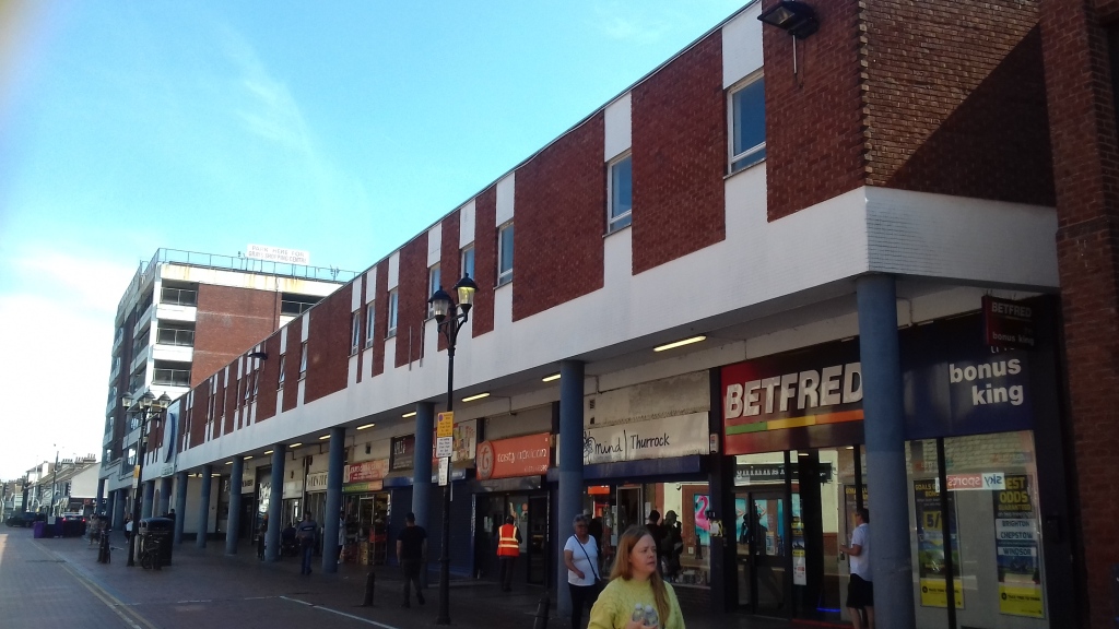
In the 1970s there was an attempt to boost the High Street, which at that time still had a Woolworths and Marks and Spencer, by building a small shopping mall with attached multi story car park to the rear of it. At a time when the car was still considered the future and places like Leeds were carving themselves up with urban motorways, the idea was that people would drive in, have a place to park in the multi story, and load up.
This was never fully realised even early on, the multi storey being decidedly underused, but when the Lakeside shopping centre opened 5 miles up the road by the Dartford crossing at the end of the eighties, everything shrivelled. Lakeside had big flagship stores, a wider range of everything and was not much harder to get to. Everything in the town centre moved downmarket. The vibe in the centre now, if you walk through it, is decidedly sparse. Even the Wilko has now gone.
This was the future once…
So the owners, like the owners of retail space elsewhere, are looking to realise capital and build in a customer base by building high above the shop. The ongoing income from retail however, is dwarfed by the enhanced value of the real estate. Similar schemes in North West London include the Edgware Road Sainsbury development at the Hyde – that is proceeding apace -and the Broadwalk Centre in Edgware, which is generating some opposition from people used to living in a sleepy greenish suburb, suddenly about to be overshadowed by 20 storey towers.
The Grays Plan is not quite so gargantuan, but envisages, modern high rise blocks around a square. You can see an idealised version in their video here, complete with weird holograms of oddly shaped people doing strange things.
Their description of their plan has the same slightly corporate unreality as the holograms in their video.
Key features of our proposals:
- Enhance and revitalise the town centre and public square
- Re-invigorate the retail and leisure offer
- Boost the night-time and leisure economy within the town
- Create space for community use and independent-focused retail
- Create a vibrant and safe public realm with open spaces and increase biodiversity in the heart of town
- Bring forward new homes in an accessible and sustainable central location
- Improve pedestrian connectivity across the town
- Introduce design-led, landscaped spaces for the whole community
- Facilitate pedestrian linkages with the Thameside neighbourhood
- Support the creation of new jobs and opportunities
All this is currently being discussed and I think the apposite questions are these. So, I have sent them in, and await a reply.
- How many people, roughly, do you envisage will be living in the development?
- What proportion of the development will be social housing for affordable rent? If there are any, will these be of the same quality as the rest of the development and integrated into it?
- Related to that, what proportion of the apartments will be for sale at what sort of prices?
- Will there be a residence requirement to avoid people buying higher end flats as an investment and leaving them empty (as is far too common in London).
- What does the proposed “space for community use” consist of? Will the public square be public or will it be privately owned?
- How will the development increase the biodiversity of the town centre?
- Will the apartments be zero emission ?
- I note that you say that, given the proximity to good public transport links, many people will have no need of a car but, if enough of the flats are high end, most of the people who live in them would probably want one, especially for leisure use. Would you consider building a car share club into the development to minimise the amount of space needed for car parking – and help pull the residents together into a community?
The developers will probably want as many expensive flats as they can get, which will build in a well heeled consumer base above the remaining retail space on the ground floor and maximise their revenues from sales. But this will be in a tension with the pressing housing need in a fast growing borough, with people spilling into it from London in a very steady stream* looking for somewhere more affordable to buy or rent. How this tension works out will determine what this development becomes.
*The ONS used to produce a migration flow maps for local authorities – sadly discontinued after 2020, which showed that when people leave Thurrock they go all over the place, but nearly everyone who moves into it does so from London.
